
Pirttisaari by boat – a fortress island and a picnic in the outer archipelago
Pirttisaari (Swedish: Pörtö) is an island in the outer Porvoo archipelago with a recreation and nature conservation area managed by Helsinki-Uusimaa Outdoors (Uuvi) and Metsähallitus. The island's sheltered Svartviken bay has a jetty that is popular with boaters, and the island has coastal guns, bunkers and a fire control tower left over from its time as a fortress island.
Details checked against sources in October 2026.
Services on site
- Guest jetty
- Toilet
- Barbecue area
- Nature trail
- No water point
- No fuel
Many services are only open in the summer season, so check opening hours on the destination's website.
Why go to Pirttisaari?
Pirttisaari lies in the outer Porvoo archipelago, about five nautical miles from the mainland. The island has been permanently inhabited since the early 18th century, when Estonian war refugees settled there, and the islanders lived mainly by fishing. Today the island has about ten year-round residents and many times as many summer residents.
In the 20th century Pirttisaari was a fortress island of the Finnish Defence Forces, and military barracks and fortifications were built in the south-eastern part of the island during the Second World War. The former military area is now used for recreation. The island still has three coastal guns, bunkers and a fire control tower, which are military history monuments.
The island's lush forests give way to smooth, flat rocks on the shores and to high cliffs in the south. In the rocky forest of the recreation area stands a wooden cross erected in 1838, and from the rocks you can see out to sea as far as Söderskär lighthouse.
There are few services on the island, but all the more peace and quiet. Pirttisaari suits a picnic trip that combines military history, walking and the scenery of the outer archipelago.
Up-to-date information
- Pirttisaari recreation area – Luontoon.fi (opens in a new tab)
- Route from Svartviken to Lerviksudden – Luontoon.fi (opens in a new tab)
- Pirttisaari – Helsinki-Uusimaa Outdoors (opens in a new tab)
- Management and land use plan for the Pirttisaari recreation area – Metsähallitus (opens in a new tab)
- Pirttisaari (Porvoo) – Wikipedia (opens in a new tab)
Who is this trip for?
The trip suits people interested in military history and nature, and anyone who wants to spend a peaceful picnic day in the outer archipelago without services. A connecting ferry also runs to the island daily from Kalkkiranta in Sipoo, so you may meet other visitors on the island.
Route to Pirttisaari
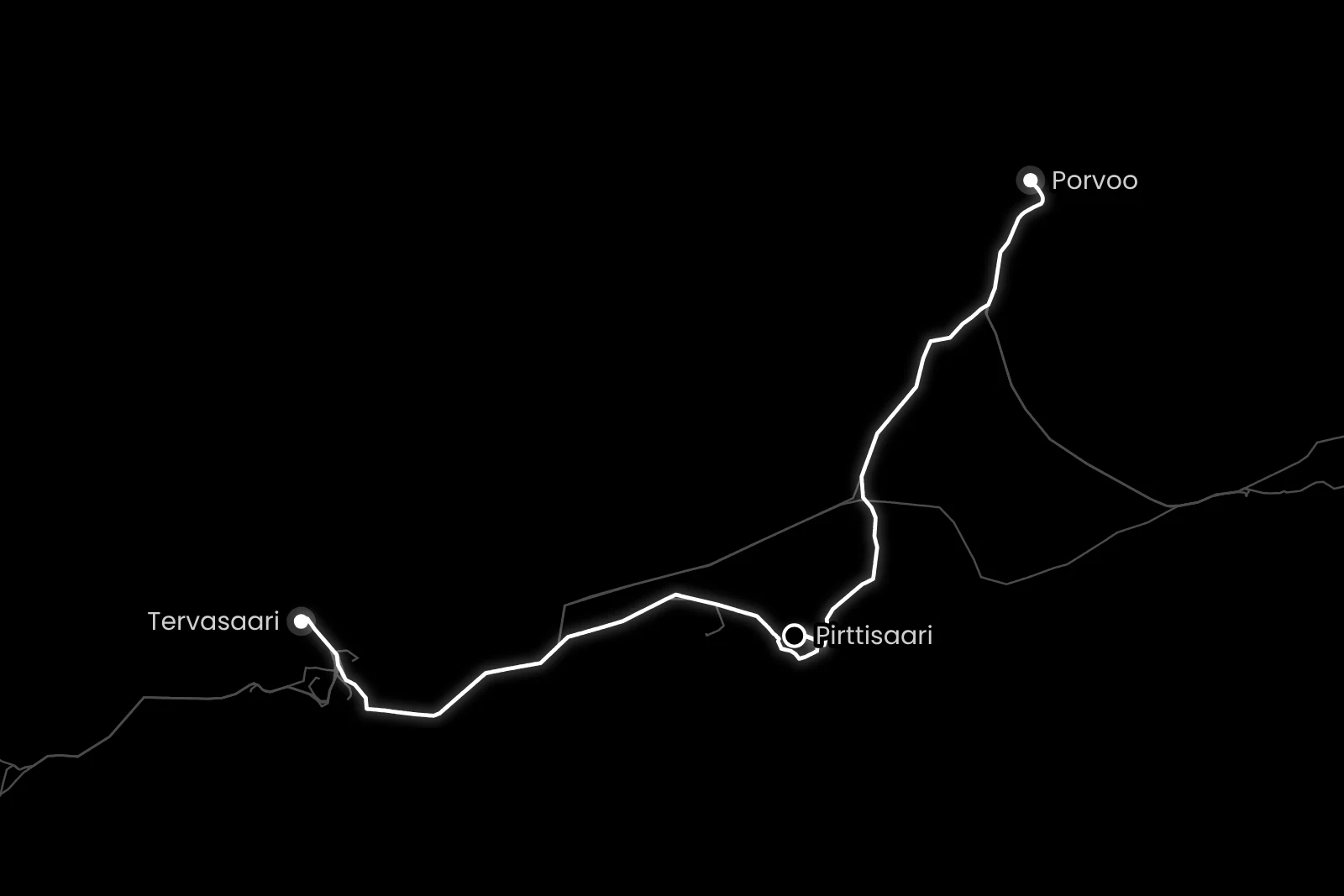
Porvoo → Pirttisaari
- Distance / one way
- 17 nm
- Travel time / one way
- approx. 1 h 15 min
- Fuel / one way
- approx. 16 l
- Fuel / round trip
- approx. 31 l
Travel times are calculated at a cruising speed of 25 knots and include the slower sections of the route. The fuel estimate is based on a consumption of 0.9 l/nm. Actual consumption depends on the boat, the weather, load and driving style.
There are routes to Pirttisaari from both the Porvoo guest harbour and Tervasaari in Helsinki. From Porvoo you first go slowly down the Porvoo River, and from Helsinki there is a section at a lower speed at the start of the route off Helsinki. Both routes also have a short slower section along the way, and at the very end you go very slowly as you enter Svartviken bay. The slower sections are included in the estimated travel time. The Svartviken jetty is deep enough even for larger keelboats, but enter the bay calmly and follow the nautical chart.
Loading the map…
Travel times are estimates without stops and depend on the conditions. The round-trip fuel estimate assumes you return the same way. Also allow time for the destination itself.
Wind forecast: Pirttisaari
Loading the wind forecast…
Suggested plan for a day trip
This is a flexible idea for a self-guided day trip to Pirttisaari.
- 01
Choose a departure point, Porvoo or Tervasaari in Helsinki, and look at its route and estimated travel time.
- 02
Pack a picnic and drinking water, as there is no drinking water on the island.
- 03
Moor the boat at the Svartviken jetty.
- 04
Walk along the cart tracks to Lerviksudden at the southern tip of the island and, on the way, take a look at the gun positions, bunkers and fire control tower from the outside.
- 05
Have a picnic at the cooking shelter at Lerviksudden or on the shore rocks, and look for the wooden cross erected in 1838.
- 06
Start the return trip in good time, taking into account the weather and the boat's return time.
Svartviken jetty
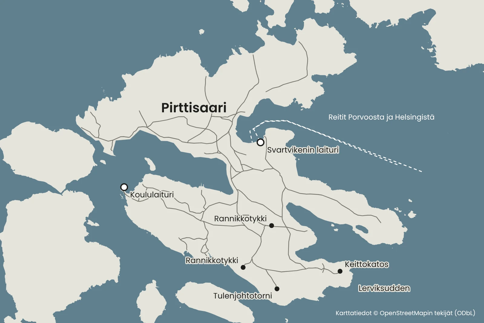
The best place to land by boat is the jetty in Svartviken bay. The jetty is sheltered and popular with boaters, and it is deep enough even for larger keelboats. The jetty has 17 berths, 3–4.6 metres wide, and one 15-metre berth for mooring alongside. There is a campfire site and a toilet near the jetty.
The jetty of the former coast guard station at the head of Svartviken bay is privately owned, so do not moor there. You may keep your boat in the recreational harbour for a maximum of two days.
Cart tracks lead to Lerviksudden at the southern tip of the island from the Svartviken jetty and from the Byviken School jetty, where the connecting ferry stops. It is about 1.6 kilometres from Svartviken to the cooking shelter at Lerviksudden. Byviken village is a built cultural environment of national significance, and the routes pass close to residents' yards, so respect their privacy as you go. The island's old school building is privately owned.
Services and rules
Lerviksudden has a cooking shelter and a toilet, and near the Svartviken jetty there is a campfire site and a toilet. The recreation area has no well and no waste bins, so bring your picnic and drinking water with you and take your rubbish away.
The gun positions, bunkers and fire control tower are military history monuments. Look at them from the outside and do not go inside the military buildings.
The shore rocks can be slippery, especially in the rain. Make fires only at the permitted campfire sites. Check for a wildfire warning before making a fire: under the rules of Helsinki-Uusimaa Outdoors, all fires are prohibited while a warning is in force, including twig stoves and disposable barbecues.
Agree on refuelling with the boat's owner before you set off.
Up-to-date information
Remember before you set off
- A picnic and drinking water for the whole day.
- A rubbish bag so that you can take your rubbish back with you.
- Sturdy shoes for the paths and shore rocks.
- Agree on refuelling with the boat's owner before you set off.
Shall we head to Pirttisaari by boat?
Rental boats in the Porvoo–Loviisa area and the Helsinki region are listed on Friilo. Agree on the boat's pick-up and refuelling with the boat's owner.
See also
- PorvooPlan a boat day to Porvoo from Tervasaari in Helsinki. See the route, travel time and tips for the guest harbour, the Old Town and the cathedral.Read the trip guide
- SvartholmaPlan a boat day to Svartholma from Porvoo. See the route, travel time and tips for the guest jetty, a walk around the fortress and the summer restaurant.Read the trip guide
- LoviisaPlan a boat day to Loviisa from Porvoo. See the route, travel time and tips for the Laivasilta guest harbour, the maritime museum and the Old Town.Read the trip guide
Similar destinations by theme: Short boat trips